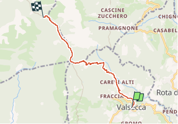
![](/images/other/stat-length.png)
![Trail On foot Sant'Omobono Terme - Sentiero 575: Valsecca - Rifugio Capanna Alpinisti Monzesi - Photo](https://media.geolcdn.com/t/1900/400/b3ff494c-2581-4b0a-a6cd-25ad3d352528.jpeg&format=pjpeg&maxdim=2)
Sentiero 575: Valsecca - Rifugio Capanna Alpinisti Monzesi
SityTrail - itinéraires balisés pédestres
Tous les sentiers balisés d’Europe GUIDE+
![Length](/images/other/stat-length.png)
![Max alt](https://static1.geolcdn.com/siteimages/upload/files/1508320355ic_sort_altitude_max_24dp.png)
![Uphill gradient](https://static1.geolcdn.com/siteimages/upload/files/1508320355ic_sort_den_pos_24dp.png)
![Km-Effort](/images/other/stat-length.png)
![Min alt](https://static1.geolcdn.com/siteimages/upload/files/1508320355ic_sort_altitude_min_24dp.png)
![Downhill gradient](https://static1.geolcdn.com/siteimages/upload/files/1508320355ic_sort_den_neg_24dp.png)
![Boucle](https://static1.geolcdn.com/siteimages/upload/files/16400158638029165_repeat_loop_refresh_sync_direction_icon.png)
![On foot](https://static1.geolcdn.com/sitytour/trail-icons/100.png)
2h39
Difficulty : Easy
![Scan this QR Code to open this trail in the SityTrail application](https://capi.geolives.com/qq0zvz2zws4bq2lad0pu/sitytour/trails/3112354/qr.png?size=200)
FREE GPS app for hiking
About
Trail On foot of 4.8 km to be discovered at Lombardy, Bergamo, Sant'Omobono Terme. This trail is proposed by SityTrail - itinéraires balisés pédestres.
Description
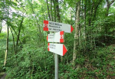
Dalla frazione Carevi Alti (692 m), il sentiero sale lungo zone a prati, a fianco di varie baite. A quota 800 m circa si entra nel bosco e si continua a salire fino ad incontrare Casa Settimo (incrocio sentiero 576 che scende a Brumano) e, a poca distanza, il valico de La Passata, dove confluiscono diversi sentieri (1244 m - vedi ivi lo storico "Termenù" - cippo confinario -
Website: http://geoportale.caibergamo.it/sentiero/575
Positioning
Comments
Trails nearby
![Trail On foot Calolziocorte - Sentiero 801: Sentiero della valle San Martino - Photo](https://media.geolcdn.com/t/375/260/3e10b426-148b-4fde-88cc-6904e8efdfd2.jpeg&format=jpg&maxdim=2)
![On foot On foot](https://static1.geolcdn.com/sitytour/trail-icons/100.png)
On foot
![](/images/other/stat-length.png)
![](https://static1.geolcdn.com/siteimages/upload/files/16400158638029165_repeat_loop_refresh_sync_direction_icon.png)
![Trail On foot Costa Valle Imagna - Sentiero 801C: Ripetitori (Valcava) - Convento del Pertus - Photo](https://media.geolcdn.com/t/375/260/bc854a3c-84b8-45d7-a03f-9dd7f589afe9.jpeg&format=jpg&maxdim=2)
![On foot On foot](https://static1.geolcdn.com/sitytour/trail-icons/100.png)
On foot
![](/images/other/stat-length.png)
![](https://static1.geolcdn.com/siteimages/upload/files/16400158638029165_repeat_loop_refresh_sync_direction_icon.png)
![Trail On foot Calolziocorte - Sentiero 801A: Ponte Serta (Calolziocorte) - Ponte Contrada (Torre de' Busi) - Photo](https://media.geolcdn.com/t/375/260/b6e4df54-c73f-41dc-867b-e80432539ddd.jpeg&format=jpg&maxdim=2)
![On foot On foot](https://static1.geolcdn.com/sitytour/trail-icons/100.png)
On foot
![](/images/other/stat-length.png)
![](https://static1.geolcdn.com/siteimages/upload/files/16400158638029165_repeat_loop_refresh_sync_direction_icon.png)
![Trail On foot Erve - Sentiero 831: Cappella del Corno (Erve) - M. Spedone - Nesolio - Erve - Photo](https://media.geolcdn.com/t/375/260/c22af308-c393-4424-b1e9-a24d00feb4e3.jpeg&format=jpg&maxdim=2)
![On foot On foot](https://static1.geolcdn.com/sitytour/trail-icons/100.png)
On foot
![](/images/other/stat-length.png)
![](https://static1.geolcdn.com/siteimages/upload/files/16400158638029165_repeat_loop_refresh_sync_direction_icon.png)
![Trail On foot Calolziocorte - Sentiero 812: Lorentino (Calolziocorte) - Passo della Pertulena - Photo](https://media.geolcdn.com/t/375/260/eb5832e0-a2cb-4ebf-bd27-87676c1ea21c.jpeg&format=jpg&maxdim=2)
![On foot On foot](https://static1.geolcdn.com/sitytour/trail-icons/100.png)
On foot
![](/images/other/stat-length.png)
![](https://static1.geolcdn.com/siteimages/upload/files/16400158638029165_repeat_loop_refresh_sync_direction_icon.png)
![Trail On foot Carenno - Sentiero 811: Carenno - Colle di Sogno - Pertüs - Photo](https://media.geolcdn.com/t/375/260/bc854a3c-84b8-45d7-a03f-9dd7f589afe9.jpeg&format=jpg&maxdim=2)
![On foot On foot](https://static1.geolcdn.com/sitytour/trail-icons/100.png)
On foot
![](/images/other/stat-length.png)
![](https://static1.geolcdn.com/siteimages/upload/files/16400158638029165_repeat_loop_refresh_sync_direction_icon.png)
![Trail On foot Carenno - Sentiero 819: Carenno - Torre de' Busi - Photo](https://media.geolcdn.com/t/375/260/75f4d701-adad-4597-b2c8-0e35f23cd501.jpeg&format=jpg&maxdim=2)
![On foot On foot](https://static1.geolcdn.com/sitytour/trail-icons/100.png)
On foot
![](/images/other/stat-length.png)
![](https://static1.geolcdn.com/siteimages/upload/files/16400158638029165_repeat_loop_refresh_sync_direction_icon.png)
![Trail On foot Costa Valle Imagna - Sentiero 801B: Torre de' Busi - Ripetitori (Valcava) - Photo](https://media.geolcdn.com/t/375/260/b6e4df54-c73f-41dc-867b-e80432539ddd.jpeg&format=jpg&maxdim=2)
![On foot On foot](https://static1.geolcdn.com/sitytour/trail-icons/100.png)
On foot
![](/images/other/stat-length.png)
![](https://static1.geolcdn.com/siteimages/upload/files/16400158638029165_repeat_loop_refresh_sync_direction_icon.png)
![Trail On foot Berbenno - Percorso C - Photo](https://media.geolcdn.com/t/375/260/32f335d1-eb72-49e8-9257-9a91097b56c8.jpeg&format=jpg&maxdim=2)
![On foot On foot](https://static1.geolcdn.com/sitytour/trail-icons/100.png)